第一节 地理信息系统基础
四、地理信息系统的定义
地理信息系统可简单定义为用于采集、模拟、处理、检索、分析和表达地理空间数据的计算机信息系统(表1.1、表1.2)。
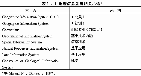
表1.2 地理信息系统定义示例*
DoE(1987:132)
a system for capturing storing checking,manipulating analysing and displaying data which are spatially referenced the Earth.
Aronoff(1989:39)
any manual or computer based set of procedures used to store and manipulate geographically referenced data.
Carter(1989:3)
an institutional entiry,reflecting an organizational structure that integrates technology with a database,expertise and continuing,financial support over time.
Parker(1988:1547)
an information technology which stores,analyses,and displays both spatial and non-spatial data.
Dueker(1979:106)
a special case of information systems where the database consists of observations on spatially distributed features,activities,or events,which are definable in space as points,lines,or areas.A GIS manipulates data about these points,lines,and areas to retrieve data for ad hoc queries and analyses.
Smith et al.(1987:13)
adatabase system in which most of the data are spatially indexed,and upon which a set of procedures operatedin order to answer queries about spatial entities in thedatabase.
Ozemoy,Smith and Sicherman(1981:92)
an automated set of functions that provides professionals with advanced capabilities for the storge,retrieval,manipulation,and display of geographically located data.
Burrough(1986:6)
a powerful set of tools for collecting,storing,retrieving at will,transforming and displaying spatial data from the real world.
Cowen(1988:1544)
a decision support system involving the integration ofspatially referenced datain a problem-soling environment.Koshkariov,Tikunov and Trofimov(1989:256)
a system with advanced geo-modelling capabilites.
Devine and Field(1986:18)
a form of MIS[Management Information system]that allows map display of the general information.
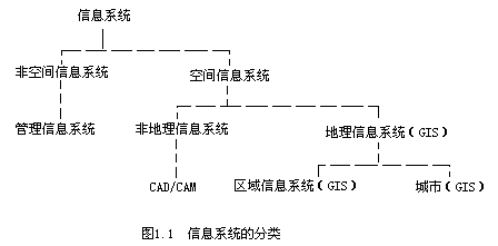
地理信息系统是有关空间数据管理和空间信息分析的计算机系统。依照其应用领域,地理信息系统可分为土地信息系统、资源管理信息系统、地学信息系统等(图1.1);根据其使用的数据模型,可分为矢量、栅格和混合型信息系统;根据其服务对象,可分为专题信息系统和区域信息系统。
与一般的管理信息系统相比,地理信息系统具有以下特征:
(1)地理信息系统在分析处理问题中使用了空间数据与属性数据,并通过数据库管理系统将两者联系在一起共同管理、分析和应用,从而提供了认识地理现象的一种新的思维方法;而管理信息系统则只有属性数据库的管理,既使存贮了图形,也往往以文件形式等机械形式存贮,不能进行有关空间数据的操作,如空间查询、检索、相邻分析等,更无法进行复杂的空间分析。
(2)地理信息系统强调空间分析,通过利用空间解析式模型来分析空间数据,地理信息系统的成功应用依赖于空间分析模型的研究与设计。
(3)地理信息系统的成功应用不仅取决于技术体系,而且依靠一定的组织体系(包括实施组成,系统管理员、技术操作员、系统开发设计者等)。
(4)虽然信息技术对地理信息系统的发展起着重要的作用。但是,实践证明,人的因素在地理信息系统的发展过程中越来越具有重要的影响作用,地理信息系统许多的应用问题已经超出技术领域的范畴。
本文标题:地理信息系统的定义-地理信息系统基础
手机页面:http://m.dljs.net/dlsk/gisdao/50327.html
本文地址:http://www.dljs.net/dlsk/gisdao/50327.html